Monday, March 16, 2015

A Dawn Elevator to Chapopote

10 March, 2015
 21o54.0' N 93o26.11' W
1859 m Depth


The elevator being launched over the side
of the METEOR just before dawn. My video
time lapse camera and other equipment
are secured to its deck. A large weight will
be released when it is time to recover the
elevator and the yellow floats will (hopefully)
bring it to the surface
The ROV has limited space to place sampling equipment and instruments. So when there is more stuff needing to go down for a dive or series of dives at a particular location, the option is to put the extra gear on the Elevator. We have arrived at the Chapopote site and will be working here for several days. My immediate research goal is to quantify the seepage rates for gas flowing out of the asphalt field. The tool for this is a video timelapse camera (VTLC) that is deployed with its own deep-sea lamp for illumination and is programmed to wake up every 5 minutes and record 15 seconds of video, then go into a rest mode until the next recording interval.

There wasn't room on the ROV to carry the VTLC to the bottom directly. So last night I started the program running and secured the VTLC to the elevator. Then we got up before dawn to lower the elevator over the side. The ship lowers the elevator down to just over the bottom, then maneuvers it to a hopefully safe location and releases it to sink the last few meters to the bottom. All this happened before breakfast.

By lunch time, the ROV was near the bottom and collecting samples. Sampling operations and exploring Chapopote occupied much of the day. Finally around 5 pm we began moving toward the site where the elevator had been placed. It took a while to find it and it was a bit of a shock when it finally came into sight. The elevator had landed on just about the only piece of open ground in the middle of a huge filed of asphalt blocks. A meter or so in any direction and the elevator would have come down on the blocks and possibly have been badly damaged.

We soon retrieved the VTLC and motored off to find a gas hydrate site where it could be positioned to monitor gas flows. Found a beautiful spot with tube worms, mussels and a big wall of exposed gas hydrate. Dropped the camera off facing a bubble stream and will come back in a couple of days to learn what it has recorded.

The video time lapse camera deployed at a gas seep in the Chapopote Asphalt field. There is a cluster of methanotrophic mussels in the foreground and chemosynthetic tubeworms all around. The trickle of bubbles the camera is watching is visible just to the left of the marker #4. We had to reposition it slightly to (hopefully) ensure a good view. We'll find out what it saw in a couple of days.


Coring for Crystals


8 March, 2015
19o58.830' N 94o10.587' W
1859 m Depth

Sometimes interesting findings come when the outlook seems least promising. Meteor had completed two TV sled tows over a potentially important site. The swath mapping showed several large circular features that resembled craters and a series of channel-like canyons with bright acoustic reflectors near the seafloor. We thought that there might be extensive asphalts and possibly exposed salt at the seafloor. However, the TV sled results were disappointing. We towed the sled 1.5 m above the seafloor for several hours in two different places without seeing any communities or definitive indication of hydrocarbon seepage. The site seemed really inactive.

The gravity core has to be rotated to bring it onboard after
collecting a core. It is a tricky job to handle the 20' pipe and
the huge weight - especially when the seas are rough.
Weather conditions were still too rough for the ROV diving so Chief Scientist Gerhard Bohrmann scheduled a gravity core targeting one of the areas of high reflectivity. A gravity corer is essentially a huge pipe with a massive weight as the top. Lowered to just above the seafloor and then allowed to sink into the bottom, a spring-like "core catcher" at the end of the pipe retains the round section of sediment that the pipe has penetrated. The German-style gravity corer is an impressive beast - a 12 cm diameter, 6 m long (5 in x 20 ft) pipe with a 2 ton stack of lead disks at the top. We lowered the gravity core 1,860 m down to the bottom and allowed it to penetrate. Then we hauled it back up again - over 3 hours for the round trip. Alas, when we inspected the core back on deck it had only penetrated about 60 cm (less than 2 ft) into the seafloor. Once again, it seemed like our sampling efforts had been defeated. But when the end of the core was examined, Gerhard discovered what had stopped the corer. The end of the core was packed with huge crystals of gypsum. The corer had been stopped by a solid layer of crystals just under the surface of the sediment!

Gerhard Bohrmann, chief scientist, pulling a section of the
gravity corer out for inspection.
This is a fascinating result. The mounds that we are investigating throughout the Chapopote region are formed by salt domes - 170 million year old salt deposits that are forced upward by the weight of accumulating sediments. Gerhard explained that when the salt comes close to the seafloor it dissolves into seawater. When all the common salt (NaCl) has dissolved, what remains is a less water-soluble salt, gypsum (CaSo4). So this layer of crystal, which must be very thick to stop a 2 ton gravity corer, demonstrates that salt was indeed near the seafloor at this site. Gypsum is also a classic cap-rock for petroleum reservoirs. In all our combined years of coring, non of us on board had seen gypsum layers like the ones we found at this seemingly inactive site.


Huge gypsum (CaSo4) crystals recovered from the end of Meteor's first gravity
core of the cruise (with a 5 peso coin for scale). The layer of crystal must have
been really thick to stop the gravity corer. Layers of rock like this are perfect
capping formations for sealing in oil and gas reservoirs. It is remarkable to
find it so close to the surface.


Tuesday, March 10, 2015

Rough Seas and Reports


20o37.710'N 92o48.406'W


We are currently under stand-by due to rough seas. METEOR is mapping the bathymetry with its swath mapping system, but it is too rough to use the ROV. For my blog today I am excerpting the ROV dive report from yesterday, when we completed a successful sampling of the bubble source that we have been exploring over the last few days. Reports like this are written for each dive. There is typically one scientist assigned to compile all the notes and prepare a summary for each dive for the log. Yesterday was my turn to be the responsible scientist and this is part of what I wrote.

Dive 352 (Station 74-1, GeoB: 19317-1)

Area:                                 UNAM Ridge

Water Depth:                   1200 - 1250 m

Date:                                 Thursday 05 March 2015

ROV in water:                 ca. 11:00

Bottom time:                    ca. 5 hours

Location ROV goes down:  19o55.856'N  94o20.550'W

Key Results:

The objective of this dive was to find and collect samples from the source of the A4 gas flare that had been identified in previous acoustic surveys. The original dive plan was to search with sonar ~10m above bottom, then to descend for sampling when the bubbles were found.

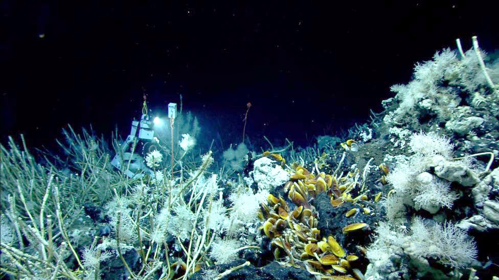
After the dive began, the sonar was not functioning, so the search proceeded visually at seafloor level. The ROV approached the A4 location from the NE and soon encountered white mats, then found a field of large asphalt boulders with extensive eipfauna (fig. 1). The seafloor was covered with mussel shells, but all appeared to be dead. After a brief exploration, we continued to a pockmark about 10m SW from the asphalt. The pockmark was steep-sided, ~1.25m in diameter and 0.5m deep, with large carbonates around and a small ridge on the upslope (southern) side of the feature. Sediments had white mats or precipitates. There were a few living mussels in the pockmark and some tube worms and several more mussels attached to the larger carbonates. A few bubbles were observed, but their source was not evident at this time. Although the ROV briefly touched the bottom, we did not land at this point. The mosaicking camera (Prosilica) was not functioning, so we could not collect down-looking images for mosaics.

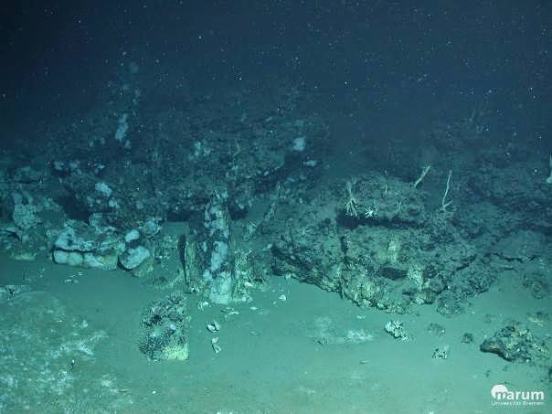
Figure 1. Asphalt with eipfauna encountered early in dive.
(Scorpio_dive352_2015_03_05  17-47-22.jpg)


We continued to explore heading SW and after about 20m came to a large area with carbonate boulders and broken pavement. Tube worms were extensive here including upright clusters of living animals surrounding an interior area with dead, recumbent worms (fig. 2). Dead mussel shells were seen within the cracks and fissures, but there appeared to be no living mussels. We continued another 15m or so until the carbonate substratum was replaced by open sediments with sparse white mats. At this point, time was limited, so we decided to return to the pockmark for our sampling.

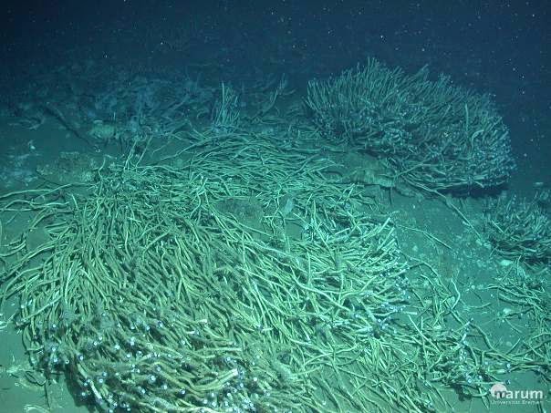
Figure 2. Tube worms and carbonates encountered SW from pockmark
(Scorpio_dive352_2015_03_05  18-05-32.jpg)
After reaching the pockmark, we maneuvered over the ridge-like feature (suspected to be hydrate) and collected a vertical profile of 7 water samples with the niskin rack at approximately 0.5, 1.5, 2.5, and 3.5 m above bottom. The ROV then backed down and landed so it was facing the pockmark heading about 060
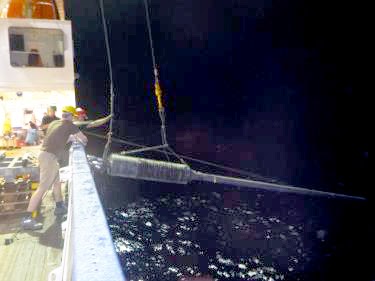
o on the downslope side (fig. 3).  Single bubbles were observed coming from a small vent mid-way up the crater wall (labeled -9 in fig. 3). The gas bubble sampler #1 was used to capture the bubbles - count 117 bubbles in total -- and then the valve was cycled open and closed to trap the gas in the pressure chamber. With time running out because of an approaching weather front, we collected carbonate rocks and a scoop net of rock and mud, then collected several mussels in two nets before terminating the dive. Copious gas and pieces of hydrate were released from the sediments as the scooping and maneuvering of the ROV disturbed the interface.

Technical discussion:

Problems encountered were non-functioning sonar and Prosilica camera. It is not clear that lack of sonar impacted the dive as the bubble source appears to have been found. A mosaic of the pockmark would have been useful. The niskin rack was successful for all 7 bottles, but a different camera placement would allow observation of all the bottles closing in case of difficulty. Avoiding contamination of the ROV by not contacting the bottom prior to water collection was highlighted by the large releases of gas during the collections. A preliminary analysis of the water samples shows near background CH4 levels despite collection next to the bubble stream. Had water been collected after the sediments were disturbed, the CH4 concentrations would unlikely have been so low. Shortening of the dive due to weather prevented collection of T-profile and push cores.

Figure 3: Pockmark sampling site with sample collections and GeoB numbers marked
See table for samples list.
(M114_dive352_cam_zeus_toolskid_2015-03-05_19-16-20.jpg)


Friday, March 6, 2015

A TV Sled and a Pelican


METEOR blog 19:00 4 March 2015
94o21'W 19o21'N


Blog author Ian MacDonald removing his VTLC camera
system from the TV sled.       Photo: SVN
We recovered the video time-lapse camera from the TV sled after a 5-hour tow across a large ridge feature we have named UNAM Ridge in honor of the Universidad Nacional Autonomos de Mexico. This site was promising because surveys in the night had identified gas flares rising from the seafloor. During the survey, we saw features that looked like asphalt, carbonate rock, and chemosynthetic fauna. But the black and white video images were poor quality and we could not be certain of what we were seeing. The next hours were occupied with reviewing the video and other survey data to choose sampling sites for the ROV dive tomorrow. The ROV crew has been really busy unloading the vehicle components from shipping containers and preparing all the systems for diving. They have been especially challenged because three members of the team are recovering from a severe flu and are only just returning to work.

                                   Freeing the pelican          Photo: SVN
Meanwhile, METEOR was adopted by a wandering bird. This pelican perched on our rail and hopped around on deck, making itself right at home. We soon noticed that it had a length of black rope wrapped tightly around its left foot. Adriana Gaytan-Caballaro, Ph.D. student from UNAM, secured its beak while members of the crew, including the captain, removed the rope. Soon the bird was hopping around the deck again, accepting a meal of a couple of fish and a nice freshwater hose down. Overnight it disappeared. Auf Wiedersehen METEOR.

A series of video clips from the TV sled showed tubeworms, massive carbonate rocks and mussel shells on and around where the bubble plumes had been spotted in the previous survey.

Tube worms, mussel shells, and carbonates seen by the TV sled
pinpoint seep location
The biological community confirms that we have active oil and gas seepage at this site. Plotting the location of the communities along the track followed by the TV sled gives us our dive target for tomorrow's ROV operation.

Getting Underway


Meteor Blog, 9:30 2 March 2015

94o20.7'W 19o55.8'N


F/S METEOR in the Port of Veracruz - she seems big
to us scientists, but tiny next to the ships that mostly come here.


There is a lot to do when moving aboard a research ship for a three week expedition. This is the start of Leg 2 of cruise M114, continuing after an 8-day mapping effort during Leg 1. F/S METEOR sat in the harbor at Veracruz for four days while containers of equipment, pallets of food and other consumables, and 28 scientists with all their instruments were stowed away and made at home. As busy as the ship was, it was dwarfed by the more usual ship traffic at the port - giant ore carriers and automobile transport ships were constantly unloading and shifting massive pieces of gear.

The customs and port control in Veracruz were very rigorous. All the crew and scientists had to sign in and out and pass through a metal detector to get into the port area. Several shipments were detained by customs until the last minute. One box full of supplies for the microbiologists were inexplicably stuck with the agents and was not released before the ship sailed.

Finally on Sunday, 1 March at 8:30, METEOR untied her lines and sailed out of harbor under sunny skies. Then we all had to get busy arranging gear and organizing our tasks. The scientists had to be briefed on shipboard life and safety. German ships are different in several ways from the U.S. scientific fleet. Meal times include breakfast, lunch, dinner, but also time for coffee and cakes at 10:00 and 15:00. The crew spaces include the mess-hall and gym, but also a cozy bar with comfy chairs and beer taps.

Chief Scientist Gerhard Bohrmann held the first of what will likely be daily science meetings. We all introduced ourselves and had a couple of nice introductory talks about past German-Mexican-American expeditions and the results of Leg 1. The overarching idea for this cruise is that the southern Gulf of Mexico hosts the largest and most extensive series of asphalt volcanoes known to science. These deep-sea features are unusual in that massive eruptions of asphalt generate rock-like, chemically active substrata that become the habitat for a diverse and productive ecosystem. Our mission over the next three weeks is to explore and quantify dozens of possible features to learn about the geology, chemistry, and biology.

This blog will explain more details of what the many scientists and technicians are doing. I feel like so many things have already happened! But for now, the important thing is to get everything organized and ready to go. And write this first blog piece so I don't fall any further behind.

While not in meetings and briefings, I spent Sunday assembling my video time lapse cameras, a high resolution macro camera, and rack that holds a series of niskin bottles (water samplers). It was well pas 22:00 when I sat down on the back deck with the ROV crew and had a Budweiser - no, not the pale American version, but the original Czech beer!

This morning I was up at 05:00 to attach one of my video cameras to the METEOR's TV sled. All night long, the acoustic survey team searched for traces of bubbles in the water column and came up with three "hot spots" where the echosounders spotted "flares" of bubbles rising from the seafloor.

Heiko, Adriana and Hubart monitoring the TV sled.
Asphalt at last.
We launched it around 06:00 and now as I sit and type this we are watching fuzzy black and white pictures of the ocean bottom, more than 1200 meters deep, slowly pass under the TV sled's camera. The sled has weight hanging from a 1.8 m long piece of rope. The seafloor appears to rise and fall as the swell lifts the sled and then lowers it down again. So far we found several large fields of asphalt with seafans, shells, and possibly some tubeworms. We will have to wait until the camera is recovered to look at the HD video from my camera and get a more precise description. But after weeks of planning and days of setting up, we're finally on-station and doing our job.